top of page

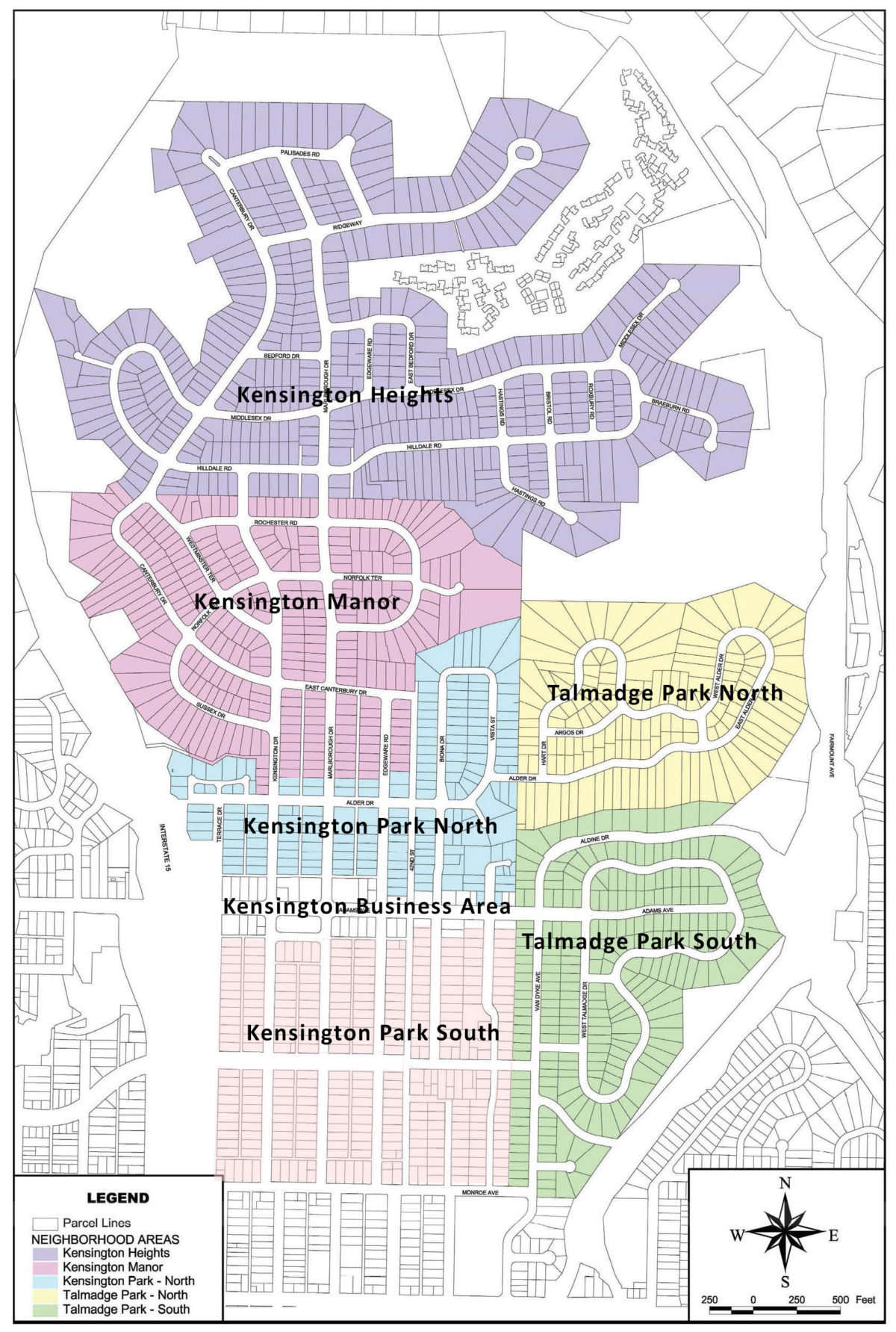
Historic Kensington District Map
Click map to enlarge.
The map below shows the extent of the proposed historic district. The proposed historic district covers 1650+ buildings, 7 sites, and 1 object. The historic district encompasses the Kensington mesa north of Monroe Ave.
Street addresses in map
Street | First Address | Last Address | Number of Properties |
|---|---|---|---|
42nd Street | 4516 | 4581 | 10 |
Adams Avenue | 4050 | 4387 | 62 |
Alder Drive | 4038 | 4389 | 50 |
Aldine Drive | 4304 | 4305 | 2 |
Argos Drive | 4303 | 4391 | 26 |
Bedford Drive | 4107 | 4180 | 14 |
Biona Drive | 4612 | 4896 | 67 |
Biona Place | 4202 | 4284 | 10 |
Braeburn Road | 4401 | 4471 | 19 |
Bristol Road | 5000 | 5187 | 22 |
Canterbury Drive | 4810 | 5374 | 108 |
Copeland Avenue | 4503 | 4568 | 19 |
Copeland Place | 4214 | 4236 | 3 |
E. Alder Drive | 4801 | 4891 | 26 |
E. Bedford Drive | 5150 | 5195 | 11 |
E. Canterbury Drive | 4156 | 4186 | 6 |
E. Palisades Road | 5302 | 5351 | 9 |
E. Talmadge Drive | 4537 | 4697 | 58 |
Edgeware Road | 4507 | 5191 | 94 |
Hart Drive | 4803 | 4895 | 38 |
Hastings Road | 5001 | 5191 | 26 |
Hilldale Road | 4057 | 4391 | 73 |
Kensington Drive | 4502 | 5040 | 110 |
Lymer Drive | 4110 | 4165 | 17 |
Madison Avenue | 4108 | 4241 | 16 |
Marlborough Drive | 4502 | 5346 | 165 |
Middlesex Drive | 4107 | 4391 | 63 |
Monroe Avenue | 4052 | 4214 | 15 |
N. Hempstead Circle | 4002 | 4035 | 15 |
N. Talmadge Drive | 4304 | 4394 | 35 |
Norfolk Terrace | 4124 | 4240 | 17 |
Palisades Road | 4104 | 4194 | 16 |
Park Place | 4101 | 4117 | 4 |
Ridgeway Drive | 4100 | 4380 | 34 |
Rochester Road | 4002 | 4197 | 37 |
Roxbury Road | 5150 | 5190 | 11 |
S. Hempstead Circle | 4001 | 4037 | 22 |
Sussex Drive | 4806 | 4870 | 26 |
Terrace Court | 4004 | 4080 | 8 |
Terrace Drive | 4507 | 4766 | 37 |
Van Dyke Avenue | 4501 | 4720 | 59 |
Van Dyke Place | 4264 | 4299 | 6 |
Vista Lane | 4754 | 4771 | 4 |
Vista Street | 4502 | 4890 | 85 |
W. Alder Drive | 4807 | 4884 | 19 |
W. Talmadge Drive | 4510 | 4680 | 35 |
Wesleyan Place | 4005 | 4010 | 3 |
Westminster Terrace | 4902 | 5098 | 30 |
Page 1 of 1
bottom of page